Sunday, April 5, 2015

13th Fieldwork Trip - 22nd March 2015 - Glasheen , Farmers Cross & Glenmore River

13 may be unlucky for some , but when it came to the Togher Historical Association's latest Fieldwork Trip , it proved extremely lucky in seeing the biggest attendance in close on 2 years - a total turnout of 6 - Kathleen O'Keeffe , Alex O'Keeffe ,  Eamonn Pearse , James O'Brien , Dan O'Riordan and Billy O'Brien. Unfortunately due to work and personal commitments others who had wished to participate were unable to attend. Ena Ronayne was given a special invite by the Blog but had to reschedule. So it was that the afternoon of Sunday 22nd March was given over to the 13th Fieldwork Trip undertaken to date by the Blog. A very clear agenda had been set out in advance : A return visit to the section of the Glasheen Stream between the Clashduv ( which is covered here ) and Deanrock bridges ; a first time call to the Airport Road region to investigate the Glenmore River and more besides and a look at the last of three original entrance points to Garrane Darragh House plus some other stop off points. More questions than answers presented themselves throughout the day , but the fun was in the chase and has laid the course for future trips to come.


 Clashduv Bridge post cleanup with improved flow


Close up view of old stone embankment


Alternate view of old stone embankment


First port of call was the Glasheen River or more properly the stretch which runs past Deanrock Estate  and flows under the Clashduv Road. This section of the stream was the subject of much debate in recent weeks with locals and Ex-Pats alike commenting on the acute build up of litter and debris which had been allowed accumulate to such an extent that it was blocking the flow of water. Quite aside from the health and safety aspects of this situation ; the overall ambiance of the waterway was sadly lacking and the consensus was that something needed to be done. Cllr. Fergal Dennehy came on board to instigate a clean up operation which saw great improvements. However , flood waters undid much of the work and as can be seen from the photos below , not all obstructions could be removed. One good thing from an historical perspective to come out of the revisit was the clearing back of much of the overhanging foliage on the banks which revealed a stone wall near the Clashduv  Bridge. This is under investigation by the Historical Association with two possible answers ; 1: It may well have been part of the sluice channel which existed in the old " Bog " now Clashduv Park or 2: It may be the remains of the " Rampart " which excited certain participants no end! Dan also commented on the signage on the wall of the Clashduv Bridge which is made up of a convoluted assortment of letters and numbers. Their significance is not known at this time. It should be noted here that a similar sign exists on the Woodhaven Bridge over by the South Ring Road area.


Alternate view of river under Glasheen Bridge


View of mysterious Bridge signage on opposite 
side of Clashduv Road near Clashduv Estate


Rarely seen pipe crossing on opposite side of 
Bridge running adjacent to Clashduv Estate


No visit or revisit to the Deanrock area is complete without a stop off to Devils Rock. The only surviving remnant of the Quarry , it was partially converted to an R.C. Grotto in 1988. Known as the " Citadel " in the 1950s , local myth has it , that the Corporation tried unsuccessfully to blow it up but had to give up after several attempts. Perhaps this is where its more well known moniker has its origins. To the left of the Grotto entrance are two deep drill holes. Speculation was rife as to whether they could have been drill charge holes from the aborted explosive exercise all those years ago. Billy O'Brien felt it would have been remiss of himself not to climb the rock after over 40 years!


 Rear left view of Devils Rock - Sheer climb


 Rear middle view of Devils Rock - Access climb


 Rear right view of Devils Rock - Hard climb


 Top view down of Devils Rock - well worn

 
 Billy O'Brien posing on Devils Rock 
- first time since the 1970s


 R.C. Commemorative plaque erected in 1988


 Front view of inserted R.C. Grotto with Statue


 View of Deanrock footbridge from Devils Rock


View of Clashduv Park from Devils Rock


Before the team departed , a walk through the Park was undertaken , with Dan O'Riordan  explaining to the group about recent work carried out to drain the Park with the use of underground pipes. Of course this lead naturally to the subject of the famous metal pipes which criss cross the Glasheen River by both Bridges , but more spectacularly by the Deanrock footbridge ( which is extensively documented elsewhere on the blog ). Whilst these are highly visible , it is the pipes under the Clashduv Bridge and opposite the road on its other side which are less so. Guesswork as to their usage range from electrical conduits to water-pipes to sewage pipes but the truth is still being searched for.


 Clashduv Park side of Glasheen River


 Clashduv Park side - banks foliage trimmed back


 Clashduv Park side - extensive clearance
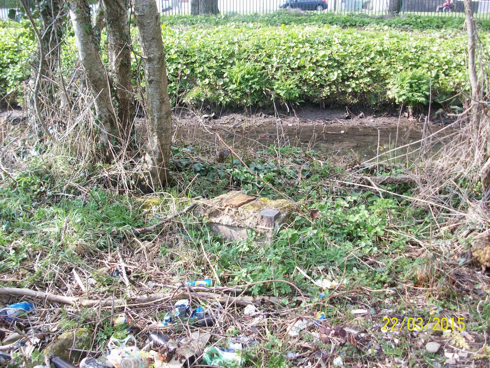

Clashduv Park side - unknown masonry 
discovered in undergrowth


With the use of two cars , the Team formed a cortege and journeyed up to Lehenaghmore and its primary destination - the Farmers Cross region. One objective were to the fore ; to photograph the Lehenaghmore streamlet which emerges as a spring to the rear of the Airport and which also acts as the physical South Eastern boundary of Lehenaghmore/Togher. Firstly , a brief walkabout of the area was undertaken by all to ascertain the boundary close up at this location. At this point , James O'Brien and Dan O'Riordan departed having prior commitments elsewhere. Undeterred the remainder of the Team set off down the Airport Road in search of the southerly Lehenaghmore Boundary. Whilst satellite GPS and Mobile Google Maps had to be brought into use because of the uncertainty of the location , other exciting finds presented themselves in the form of a forked stream and an old stone Cottage , alas outside Togher's territory but highlighting the fact that a lot of natural and man made history can be found almost anywhere one cares to look. Back on track , the group had to make do with speed flash photography from a side open car window , due to the dangerous speeds encountered on this stretch of road. The boundary of Lehenaghmore showed itself in the form of a deep ridge flanked by a hill to its north with a spring stream flowing towards the road , and presumably under a bridge ( which needs further investigation ) and onwards and following a gradient away from Togher on its opposite road side.


Farmers Cross , Lehenaghmore


Right hand side of road leading off Farmers Cross 
showing marshy ground


Left hand side of road leading off Farmers Cross 
showing scrubland


Ditch line in background marking South Eastern 
boundary of Lehenaghmore , Togher


Close up view of ditch line boundary showing 
spring running eastwards towards Airport Road


The next destination proved to be the most exciting of all as the group pulled in towards the original route the " Airport Road " would have followed prior to its straightening back in the 1960s to facilitate traffic to the new flyway. Just before the turn off from the loop back onto the main road , it was decided to stop and search for a possible bridge. What was found astounded all present and literally took their breaths away. A bridge was indeed found , looking almost Tolkien in appearance , the huge stones having partially collapsed down on themselves , their sheer weight and closeness of join literally holding the whole structure in place! A spring at the base of the rocky enclave emanated from a fissure which had discolored the face of the boulders over which it passed. The Glenmore River was a mere trickle as it appeared from the right of this feature and meandered placidly through a sandy bed. The view was heart stopping as was the height of the bank - between 40 and 60 feet down to the bottom. The slope was constituted of very fine soil which made it impossible to descend for a closer inspection. The opposite side of the road afforded a better view and also gave a good impression of the scale of the depression the River made , with the land more uneven at this juncture. A man made V-shaped structure lay at the bottom right hand side whose purpose is at present unknown. It was speculated that it could be another spring or water outlet. The purpose of the Bridge itself posed many questions , not least the difficult task of erecting it in the first place. The reason for its construction lent itself to the notion of an important access point at this part of the old road back in the 17th to 19th Centuries - crossing from Lehenaghmore into Ballycurreen and vice versa. It is impossible for the camera lens to accurately translate what the human eye can perceive as is the feeling of depth perception , but it is hoped that the photos give some clue as to what was experienced on the day. The Team then set off back down the Airport Road , paying homage to the Mass Rock , which is partially covered over by trees and vegetation on the opposite side of the road. It is thought that a cross was carved into the stone in the 1950s by an American returning home to mark the spot for posterity. Even though it lays outside Togher's boundary , it was intriguing to say the least and something for other local History Groups to investigate further.


Old stone Bridge off Airport Road 
near modern Pegasus Sculpture


Video showing old Stone Bridge 
and deep floor bed of Glenmore River


Video showing opposite side of Glenmore River 
as it rapidly descends down a steep gradient 
towards Pouladuff Crossroads , Togher


Zoom shot of spring near old Stone Bridge


Billy O'Brien on slopes of Glenmore River


Zoom shot of V-shaped water outlet on 
opposite side of old Stone Bridge


View of deep gulley opposite 
side of old Stone Bridge


As a closing statement on the last of the 3 original entrance points of the old Garrane Darragh Big House the group next stopped off momentarily at the entrance to a now private enclosure at the junction of Sarsfield Road and Togher Road ( Doughcloyne Hill ). The original roadway would have passed through here , with a high embankment to its left ( still very much in evidence ) and carried on through to the site of the present day Mormon Church and looped up and to the left of Eagle Valley and Togher Reservoir before stopping on the brow of the hill overlooking the Big House. Although 2 structures are shown to the left of the entrance on 19th Century OSi maps , it is thought they were not Lodges but rather workmens Cottages ; alas they are gone as well , supplanted by a modern Industrial Estate.


 Remnant of original Togher Road entrance to 
Garrane Darragh House off  Sarsfield Road


Opposite side of high tree lined embankment 
of original roadway to Garrane Darragh House 
from Togher Road


Kathleen O'Keeffe suggested that the Team visit a site clearance on Doughcloyne Hill before calling it a day. Previously hidden from view by considerable coverage of trees and vegetation the clearing back revealed a house. It is thought it may date back to the 1920s or 1930s. Speculation ensued as to whether this house would soon be demolished to make way for a new build. Eamonn Pearse departed at this juncture but it was decided by the remainder of the group to pay a visit to Woodhaven as Billy O'Brien was absent from the last FieldworkTrip to this particular spot.


 Old Cottage uncovered after major tree 
clearance on Doughcloyne Hill


 Billy O'Brien near iron wrought gates


 Billy O'Brien taking shelter behind pillar trying 
to capture photographs in very sunny conditions


Although heavily photographed previously , it was decided to video the Bridge and Glasheen River at Woodhaven to bring it to life on the blog. At this stage , it was decided to wrap things up and digest all that had been seen throughout the afternoons travels. The end of another fantastic jaunt around Togher.


Glasheen River in Woodhaven Estate , Togher

Wednesday, March 11, 2015

12th Fieldwork Trip - 8th March 2015 - Sandbrook & Glasheen River

On Sunday 8th March 2015 , Eamonn Pearse on behalf of the Togher Historical Association undertook a solo excursion of the site of Sandbrook Estate which is located directly across from the Sarsfield Road Roundabout. This Private Apartment Complex is bounded to the south by the main Sarsfield Road motorway and has the Glasheen River , which serves as its natural physical boundary to the North , curving gently around it on its way to Deanrock with the St Finbarr's sports ground to its immediate East.


Sandbrook circa 2009 showing Glasheen to North 
and St. Finbarrs grounds to East 
with old Sarsfield Road Roundabout to West


The Bridge which acts as the access point to the quietly secluded location has been altered in recent times from a square box shape to a rounded concrete overpass. Eamonn reminisced about childhood memories from the 1970s where children from Deanrock and other areas in Togher would travel under this Bridge in makeshift rafts on their way to the now E.S.B. Station.


 Tree lined Glasheen River marking 
the boundary around Sandbrook


 Entrance road into Sandbrook showing Bridge


Passing over bridge into Sandbrook


Approach to enclave showing Apartments 
Complex and Sarsfield Road Overpass


It was noted by Eamonn that the Glasheen River at this junction is extremely overgrown with Trees and other heavy vegetation which is in stark contrast with the scene at Woodhaven ( see here ). Below are some shots of the access bridge into Sandbrook to illustrate the current situation as it stands. It was reported to the Blog that the shell of an older Bridge existed near the E.S.B. Station and investigations are underway to locate its former location.


Overview photo of Footbridge


Close up shot of Footbridge

Tuesday, March 10, 2015

11th Fieldwork Trip - 26th February 2015 - Woodhaven & Glasheen River

Less than 2 weeks had elapsed since the last outing to Garrane Darragh " Western " lodge off the Bandon Road ( see here ) ,when Eamonn Pearse , Kathleen O'Keeffe and Alex O'Keeffe undertook a follow on field trip to investigate the former site of the now long gone " Northern " Lodge. So it was on Thursday 26th February 2015 at 4.30 p.m. that the Historical Association arrived at the Bridge in Woodhaven ( north of the South Ring Road ) which marks the area where the structure would once have stood. The actual road leading into the Estate is known locally as Garrane Lane , which hints strongly at its past connection with the Big House of the same name. Woodhaven Estate itself occupies the former entrance from a Northern aspect to the old Big House on the Hill a.k.a. the Haunted House. Where once the Cork Macroom Railway line would have dissected this patch of ground , today the South Ring Road serves the same purpose , leaving the sleepy Estate perpetually cut off from the main Hinterland. The semi circular tract of land which owes its shape to the Glasheen River and the South Ring Road is comprised on the left half by the Estate and on the right half by open grassland.


19th Century OSi map showing location visited


Woodhaven with tree - lined Glasheen River 
above the South Ring Road


The bridge itself is a modern construct , perhaps or more probably replacing an older version which most likely occupied this particular crossing in years gone by. Composed simply of 2 lateral concrete pipes running in tandem , it is back filled with cement and topped off with bricking on its upside and cordoned off above its watercourse with metal grills to prevent access underneath. Its Western bank is characterised by a concrete storm pipe protruding into the river.


Woodhaven Bridge and Glasheen River


Kathleen O'Keeffe on opposite side of Bridge


View from Woodhaven towards Woodbrook 
showing storm pipe


Site of original Northern Lodge 
near modern Bridge ( markings unknown )


Whilst the Bridge has no official name , it is proposed by the Blog for future reference , that it be called Woodhaven after the Estate around which it flows. It should also be noted that the waterway itself marks the Boundary of Togher , with all land lying to the Ring Road side belonging to that Territory.


Original gravel pathway to Garrane Darragh


Looking back on Woodhaven and old pathway


Bend in original pathway with trees 
still in situ before turn onto new riverside walk


Riverside walk near motorway
cordoned off by fence


After surveying the immediate area encompassing the bridge , Eamonn and Alex decided to travel down the tarmacadamed walkway which ran adjacent to the Glasheen River , fenced in from the nearby South Ring Road. However prior to that , an amazing discovery was made in the form of the still preserved original pathway from the bridge to Garrane Darragh house off in the distance. Sadly , it is terminated by the new carriageway but has a new lease of life as a riverside stroll.  The stream in this region is a boon for local waterfowl , and the banks are tastefully decorated with birdboxes while at various fording points can be found child fashioned swings. An extremely peaceful and serene location which flows mere yards from a modern motorway! A brisk stroll was made as far as the E.S.B. station and then a return to Woodhaven Bridge.


 Swing across ford in river


 Bird box in treetop


Approaching E.S.B. Station


Eamonn completed a portfolio of snapshots of the walkway in both directions which serve as a probable example of what the entire River in perhaps more built up locations may have looked like pre - local development. It is important to state that the Glasheen River begins up by the Airport and runs in a gigantic loop until it reaches Clashduv Road Bridge , along the way , acting as the natural physical border of Togher up to that point.


Beautiful natural habitat for waterfowl


 Unspoilt watercourse with Woodhaven seen afar


Grassy bank along Glasheen River - Woodhaven


As a footnote , the team also revisited the site of Kelly's Cottage ( see here ) off Matthew's Hill to investigate further inland where Google Maps back in 2009 showed 2 derelict structures. Alas , none could now be found. Again , a red alert issue to the Historical Association reinforcing the fact , that a photographic survey of the entire hinterland must be completed as a matter of urgency , given the fast changing pace of the landscape!

Wednesday, February 25, 2015

The Five Star - A Special Photograph

While the Blog will endeavor to publish many articles in the future on the now defunct Southside Shopping Centre which was once located on the site that Lidl now occupies , perhaps its original anchor tenant is the one which elicits most memories from Togher residents and ex-Pats - the Five Star - which also went by the local moniker of the " Fiva ". This Supermarket chain opened in 1970 heralding a new localised shopping experience for the suburb which was still in its infant stage as a modern district. Rising , like its sister units which ran adjacent to it , from the ashes of the former Clashduff House , it soon became an important feature of Togher. Managed by Mr. Charlie McCarthy a.k.a. " Macker " and staffed by locals on a full and part time basis , it integrated into the community seamlessly. Complete with its coffee dock and up to date stock , it was viewed as a Metropolis by long time residents all over Togher , who could now shop nearer to home. It rightfully lays claim to being the first suburban Shopping Centre in Cork City!


Five Star in its prime back in the 1970s


Sadly , with the advent of competition , in the wake of the new Togher Shopping Centre next to Ardmanning House which opened the following year in 1971 and the new gigantic Wilton Shopping Centre which opened its doors to Cork City in 1977 , the end was in sight for the " Fiva " and it pulled down its shutters for the last time as it entered the 1980s. As quickly as it had emerged , so too did it disappear. Aside from several local enterprise schemes which utilised the empty husk , it finally submitted to the wrecking ball in 2005 and another Togher institution was erased forever from the landscape.


Former Five Star seen on left in the 1990s


While outside photographs of the Supermarket are thin on the ground , it could be declared that inside ones are ultra rare! However , Anna Marie O'Shea was kind enough to loan the Historical Association an absolute gem! Back in 1971 , the Five Star ran a local promotion ( thought to celebrate its official opening ) by staging a supermarket trolley run , with the grand prize being a new oven. The winner was Mrs. O'Shea , Anna Maries Mother and part of the fantastic gift was a large black and white photograph , showing the Manager , Mrs O'Shea and her Daughter , Anna Marie , with Garda Bill Daley on left ( All Ireland road bowling champion ) & Charlie McCarthy on the right ( St. Finbarrs & Cork hurler ) on hand to present the prize. In the background are some locals , unknown at this time , though speculation is rife as to who they actually are.


Eamonn Pearse posing on exact location 
of old Five Star with original photograph


Eamonn Pearse , photographer with the Historical Association undertook a labour of love in restoring the 40 plus years old artifact to as pristine a condition as was possible with the aid of modern technology. Many hours were spent taping the badly damaged paper back together and photoshopping completed the task to bring it literally back to life. Below can be seen the process as it transformed from mere pieces to ultimately a piece of history which can now be enjoyed by all. The Blog would like to extend their gratitude and thanks to Anna Marie O'Shea and Eamonn Pearse.


 Original condition photograph


 High quality restored darkened version


Lightened version to show 
background detail in more clarity