Showing posts with label Gortagoulane. Show all posts

Friday, March 11, 2022

Townlands - 12/15 - Gortagoulane

 Gort an Ghabhláin - Field of the Fork - 401 Acres


Gortagoulane - ( Data from Townlands.ie )


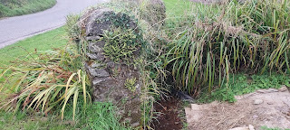
Gortagoulane is thought to have been the seat of the Ui Mc Ceir tribe up to their eventual loss of power in the late 1100s. The fork in its title refers to the various streams which virtually encompass the land ; the Liberty stream which rises at its south eastern tip and flows under Corcoran's Bridge ( built by journeymen masons in the 18th Century and named after the farmers who commissioned its construction ) in a northerly direction meeting up with a winterborne stream which rises near its western boundary and an internal stream which rises inside its territory. The Glasheen River acts as its southern boundary with Doughcloyne making up its western boundary. The land to its extreme north is marsh or bogland and a possible fulacht fiadh ( ancient pit which was used for dyeing , bathing and brewing ) is located on its land where the Gortagoulane stream and the Liberty stream meet.


Remains of old Ashgrove Farm


Gortagoulane stream meets Liberty stream
( Probable site of Fulacht Fiadh )
 

Derelict houses ( bought by Cork Airport ) near Corcorans
Bridge ( Possibly dwellings of Corcoran Brothers? )

There are 2 old houses named Ashgrove House and Ashgrove respectively which appear on 19th Century maps and are farmsteads. Another older residence once existed inland and which was accessed via a long laneway from Lehenaghmore before encountering a lodge ; this was Ashgrove Farm and all that remains of the structure are two right angled high stone walls. The land today houses Richardsons farm which is accessed from Doughcloyne and some private dwellings. In 1911 Census there was a total of only 8 inhabited houses in the entire Townland. Gortagoulane has two internal roads , Matthews Hill ( which emerges from Lehenaghmore and bisects the Townland as it exits ) and Wilson's Lane ( Ashgrove Close ) a.k.a. Ben Deebles Lane. The Townland's south eastern portion takes in part of the runway of Cork Airport.

Corcorans Bridge

Addresses ( Modern Era )

Wilson's Lane
Ashgrove Close
Matthews Hill
Ashgrove House ( Farm )
Ashgrove ( Farm )


Addresses/Structures ( Historical Era )

Fulacht Fiadh
Ashgrove House ( 2 walls remaining )
Corcoran's Bridge

Boundary

From a point near the airport following the Liberty Stream in a northerly direction under Corcorans Bridge to meet with the Gortagoulane Stream and following the direction of the old winterborne stream westwards in a meandering manner southwards until the access road/lodge into Richardsons Farm before moving southwards again to Wilsons Lane before joining the Glasheen River a little further on and tracing the stream all the way back to the Airport where it rises near the Liberty Stream.


Saturday, September 25, 2021

32nd Fieldwork Trip - 25th September 2021 - Kilmurriheen & Togher Culvert

On 25th September 2021 , Togher Historical Association traveled to the Townland of Kilmurriheen to meet with local Oran O'Connell to learn about the local history of Togher's southernmost region. Lying in the R.C. Parish of Ballinhassig , the area nonetheless identifies as Togher with provenance being provided by the natives of the Townland. Kilmurriheen has one short through road which begins at Liberty Bridge and ends at Peggitty's Cross. The land stretches on one side right down to the Bandon Road ( just after Maxol garage ) and on the other to Knockalisheen. The group began their journey with Oran acting as guide throughout at Liberty Bridge which is listed on old OSi maps and one of the few named bridges in the Togher district as a whole. The stream which also takes the name of Liberty ( not to be confused with the Liberty stream which flows under Corcoran's Bridge ) rises not far from the bridge and flows under a specially constructed arched brick wall adjoined to the residence of the Neff family.


Liberty bridge at Kilmurriheen


Side view of bridge with Liberty stream


Arched brick wall of Neff family to rear of Liberty stream
 
 
The team then made their way to the end of the Townland at Peggity's Cross. Here they saw the now disused " Flapper " track used by coursing clubs back in the 1960s and 1970s. A Flapper track was an unofficial training ground which was used to test the speeds of dogs. The sheds in which the dogs were kept are still intact though the soft boggy ground in front of them is now heavily overgrown. Oran explained that further up the road there used to be a gate into the field. Contact was made with local Denis Bradfield who once worked for the Ordnance Survey. He explained that although the Townland was in a different Parish , it was was still very much part of Togher.


Peggity's Cross , Kilmurriheen as seen from outside Townland


Dog sheds as seen from roadside


Alternate view of dog sheds
 
 
Kathleen O'Keeffe
Togher Historical Association
Peggity's Cross , Kilmurriheen
 
 
Oran took the team through a whistlestop tour of the locality name checking all the landowners and residents in the Townland and even beyond. The townland was divided up on the left hand side moving away from Peggity's Cross towards Liberty Bridge between the O'Briens and the O'Learys. Land on the opposite side was partially owned by O'Carroll and Kingstons. He recalls working during the summer as a youth for a local farmer where he would assist in the daily milking of up to 400 dairy cows. He explained that his family originally hailed from Barracks St. until they moved to Greenwood Estate in 1980 for a short time before moving to Kilmurriheen in the mid 1980s. Several milk churn concrete rests were pointed out along the way. Oran explained that dairy farmers would use these to load and offload the heavy milk churns from carts and later lorries.


Milk churn rest in Kilmurriheen


Milk churn rest hidden in ditch


Oran explained that there was a group of 7 cottages built on private plots grouped together on the eastern side of the Townland all built between the mid 1970s and 1980s. His Parents still reside there. The rest of the various houses peppered around the Townland are the siblings of the various local Farmers. The team made a final stop off once more at Liberty Bridge. Here Oran mentioned that the old cottage was used as a stables/storeroom by the Kingstons who are renowned Holstein Cattle breeders. Another surprising discovery was made later on as the group moved away from Kilmurriheen when a house fronting onto the road displayed the title of a Townland - Gortagoulane! The only known instance of a Townland title being displayed on a house.

 
Old Kingston cottage near Liberty Bridge
 

Gortagoulane signage on house


The group eventually made their way to Togher Road to quickly take in the progress being made on the Culvert. Of particular interest was the gully near Greenwood Estate. The stream bed was now completely dry and devoid of water for the first time since the 1840s. An opportunity not to be missed presented itself with a surreal walk through of the gully. It is thought that there are plans to completely infill the dry gully which will see the arched bridge disappear underground forever never to be seen again. Another old bridge near the Community Centre has now been irretrievably lost. 2 videos shown below display the gully in its dry state and will in time become important historical mementos of a bygone age.


Culvert under construction towards Togher Cross
 
 
View of dry gully from entrance to Greenwood Est.

 
View of dry gully from Togher Road


Inside the gully looking back to the overhang slab
 
 
Inside the gully looking towards the arched bridge


Video inside the gully of the arched stone bridge
 
 
Video inside the gully showing the concrete overhang