On Wednesday , 16th February 2022 , Togher Historical Association took to the road for the first time since September of 2021 to record the progress of the ongoing culvert works on Togher Road. The immediate and stark changes which presented themselves was the filling in of the Gully by Greenwood Estate next to the Garage and the removal of the old stone wall completely. ( There is a raised surface now present which may accommodate street furniture and a lower hardcore base for a new pedestrian walkway ). Coupled with that was the culverting of the section of stream by Togher Cross and the disappearance of the old beveled stone wall and the cutting down of the trees which lined its banks. The last two sections of stream to remain daylighted since the 1840s was now erased from history and from sight. Liberty Stream a.k.a. Togher Stream is now no longer visible from Togher Cross to Coffey's Field. The New Culvert which has its beginnings alongside the old Southern Fruit Industrial Estate is a mind blowing 4 Metres Wide by 4 Metres Deep and follows a largely linear trajectory from Togher Cross to the Community Centre where it makes a sharp turn to run along Coffey's Field. The section of New Culvert by Southern Fruit is still under construction and will alter the original Stream's flow there into the concrete channel which also has an overflow culvert to cater for sudden rises in water.
Old gully filled in near Garage ( looking North towards Greenwood Estate )
Old Gully across from School ( Looking back towards Garage )
Looking towards Togher Cross ( Lanes old cottage on corner )
View of Lanes cottage and garage ( Lehenaghmore Road side )
Side view of Lanes cottage and Garage ( Looking back from Lehenaghmore Road to Togher Cross )
Close up view of Lanes garage and covered stream
Alternate view of Lanes cottage and Garage ( Lehenaghmore Road looking towards Togher Cross )
Close up view of Lanes cottage
Location of New Culvert by Southern Fruit
Original Togher Stream next to Southern Fruit ( To be culverted into new concrete channel - see next photo )
Culvert section under construction next to Southern Fruit ( Overflow channel on right )
Interior shot of Overflow Channel
1980s Pipes next to Southern Fruit ( Originally daylighted near stream on Togher Cross )
The group next made its way to the rear of SuperValu for a look at a piece of hisstory hidden in plain sight. The area on view in the photos was once known as Minnie's Orchard and existed right up to the 1960s when the road facing walls were demolished to make way for the then new Togher Shopping Centre in 1968. The surviving walls are encircled by Earlwood Estate which was built between 1958 and 1962.
Original stone wall to rear of SuperValu
Old stone wall to rear of Earlwood Estate
A spot check was made on some of Togher's remaining historical houses on Togher Road and Pouladuff Road. First on the list was a visit to the two storey semi-detached house on Ardmanning Hill which features in the famous harvest photograph from the 1950s. Research is still ongoing with it presently being thought to be Russell's dairy farm. However this has not conclusively been determined. Pouladuff Road beckoned for a brief look at 3 houses which stood before any modern development pre-1960s. The Laurels which is currently for sale with rumours that it is to be demolished to make way for new builds. The house is over 200 years old and is in private ownership. Next on the right hand side past Edward Walsh Road moving south was Bellvue House , an old two storey build and finally an old cottage. Research again is underway to unearth their past.
Russell's Dairy Farm? Ardmanning Hill
The Laurels , Pouladuff Road
Bellvue House , Pouladuff Road
Old cottage , Pouladuff Road
Next stop was a visit up Lehenagh Beg to look at the old Kelly's cottage. The site has been sold and plans are underway to build 16 new houses. The old once more makes way for the new. Evidence that not only is
Togher changing , but that it is changing beyond all recognition.
Planning application near roadside
Front view of cottage
Kathleen O'Keeffe , Togher Historical Association
Land to rear to consist of 16 new dwellings
Final visit of the day was to the old railway bridge in Mahers Lane. Hard to believe that trains once ran under it and even harder to believe that it was the first time the group had looked at it. Even harder to believe is the fact that Togher still has 5 railway bridges intact! All part of the old Cork Bandon line. These will be covered in a future article.
Maher's Lane railway bridge ( uphill from Maher's Lane )
Mahers railway bridge looking back towards St James Cemetery
Togher Historical Association undertook its first Fieldwork Trip since November 2019. Due in large part to Covid-19 restrictions it was impossible to carry out any on the ground research for 2020 and much of 2021. However once the opportunity presented itself the group set out to have a closer look at the new Estates springing up in Togher with a nod and a wink towards those which have been here for many years.
Billy O'Brien , Councillor Thomas Moloney & Kathleen O'Keeffe
First port of call was to the home of Councillor Thomas Moloney on Elm Road. Thomas has been instrumental in acquiring material for the Historical Association over the years from plans of older Estates to general information including road signage and much more. The Association would like to formally acknowledge his silent contribution to the research of local heritage and to his family for welcoming them into their home.
Shournagh Grove as seen from Clashduv Road
Boulder landscape in centre of Shournagh Grove
Looking back from Shournagh Lawn
Shournagh Grove on Togher Road
Next stop was to Togher's newest Estate , Shournagh Grove. Built on the site of the Old Owenacurra Court the buildings are quite modern with solar panels installed on the roofs of all builds. The new address loops around from Togher Road , Clashduv Road and back on itself to emerge onto Shournagh Lawn and back around onto the Togher Road. While admiring the new houses , it was also discovered to have an unusual feature in the form of a rock. It is not thought this is native and may have been specially fitted to enhance the landscape.
Deanwood Avenue
During the visit , the group paused to take in some of Togher's older places. Deanwood Avenue was built in 1964 and the old tree overlooks the entrance. Carmelville is one of Togher's very few listed buildings. And last but not least , Solas , Togher's only conical shaped residence.
Carmelville
Solas ( corner of Vicars Road and Togher Road )
The group then made its way over to Togher's newest construction , the as yet unnamed Estate off Sarsfield's Road. The former scrub-land has been completely transformed and work is well underway. The land itself has been deeply excavated with the result that the houses are below the surrounding road.
As seen from side of housing scheme
Foundations in place for builds
As seen from main road
The team then made their way to the townland of Knockalisheen to capture some moments of the Glasheen River in full flow as it descends from the Airport and passes under a bridge and carries on through Morrisons Ravine towards Waterfall to begin its journey around Deanrock and on to the River Lee. Sadly a swivel gate which allows access to the Glasheen has now been cordoned off with warning signs and CCTV camera mounted on a tree.
Glasheen River as seen from roadside in Knockalisheen
Closer view of the Glasheen River
Video showing Glasheen River before it flows under bridge
Panoramic view of Glasheen River as it emerges from under bridge to flow into Morrison's Ravine
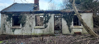
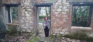
The group then made its way to the former home of an as yet unnamed family. Sadly the old building is badly dilapidated and its grounds are extremely overgrown though the locked gate looks new. A million memories have tragically been returned to nature. It is not known what future lies in store for this place which once was full of life.
Entrance to old house
Close up view of house on Spur Hill
The whistle-stop tour concluded with visits to four separate houses dotted around the region. First up was Marian House which was radically altered in 1954 and renamed to coincide with the religious festival. Next was a flyby of the home of the Walsh's , whose family were involved in the War Of Independence , a fleeting glimpse of the former labourer's cottage once the home of Mossie Sexton ; and lastly a visit to Ardan Mhuire which over the years has been home to Nuns. It is planned to present articles on each house in more detail for the blog very soon.
On 21st November 2019 , the Togher Historical Association undertook its 30th Fieldwork Trip to date. The Buildings & Bridges Tour was planned in advance of what turned out to be a very cold and wet day. However all expectations were surpassed as is usually the case when venturing out and about in Togher. First stop of the journey was a visit to the nearly completed site on the former N.B.A. flats. All evidence of their existence is now erased , even the concrete steps which lead up from the road near Clasduv Park. The team began their tour of the newly named Shournagh Grove in an anti-clockwise direction starting from the Ilen Court side and moving by road onto Clashduv Road , Togher Road and back in past Shournagh Lawn.
Corner of Shournagh Grove across from Ilen Court
View from Ilen Court looking down to Clashduv Park
View towards Abbeyville Vets
View from Clashduv Road
Junction of Clashduv Road & Togher Road
It must be stated that all the builders and security guards that were encountered along the way were extremely accommodating and informative. One security guard on Deanrock Avenue informed us that he was a Togher man who had emigrated to England in the 1980s in search of work and stayed for 30 years. Originally from Greenwood Estate , he related the quality of the buildings , including excellent insulation , solar panels and underground heating including spacious kitchens. He mentioned that the original plan was to have the scheme finished by December 20th 2019 but that due to bad weather and other circumstances that this was perhaps not now feasible. Most of the inner roads had yet to be hard-cored and tarmacced.
Corner of Togher Road / Clashduv Road
Togher Road across from Deanwood Avenue
View onto Togher Road from Deanvale
Entrance off Togher Road across from McCarthy's House
The group next moved to the other side of the Estate next to Shournagh Lawn. Here it could be seen that most of the road had yet to be treated. It was at this point that a young security guard approached us and politely explained that further access was not possible. The group engaged with him and soon struck up a conversation which resulted in them being able to take some photographs. At this stage two workers joined in the conversation and it transpired that the young man was originally from Bulgaria. It would appear he had traveled all the way to Ireland for work and met a woman from Bulgaria. The pair are now soon to wed. The workers jokingly asked if the group had been invited to the wedding. The following photographs show the view from Togher Road in and around Shounagh Lawn and a nice view of the new Shournagh Grove. A short video taken from Togher Road gives a nice representation of the new houses , many of which are already occupied.
View past Shournagh Lawn onto new Estate
Right hand side of above view
Exiting from new Estate
Corner view towards Market Gardens
Corner view looking back towards Togher Road
Short video of Shournagh Grove , Togher Road
The team then moved off to another site , the newly completed complex near Palmbury ; the former site of the Lodge which originally lead up to Lehenaghmore House. The scheme was funded by Cluid and is believed to be affordable housing. Even though it is fully completed , it is unoccupied and fenced off.
View looking back towards Togher Cross
Left side view of site
Right side view of site
Next stop was in Eagle Valley to inspect the remains of an old stone wall. Acting on information drawn from a 19th Century OSi map , this was one of several locations where the surveyors placed a benchmark. However the wall was crumbling and for the most part entirely missing. No benchmark could be discerned and the missing blocks were most likely long gone.
Old stone wall in Eagle Valley
Close up view of old wall in Eagle Valley
The group next made its way to Lehenagh railway bridge , one of the few remaining from the old Cork Bandon line. The OSi maps indicated that the benchmark was located on the right side wall of the bridge. The wall was partially covered in clinging ivy and this was torn away to uncover the hidden benchmark. At the time the idea was abandoned and it was only later after zooming in on photographs taken at the scene that the benchmark was discovered! The photos below show the benchmark in all its glory , one of only two still in existence in Togher.
Left side of Lehenagh Bridge
Right side of Lehenagh Bridge
Benchmark on Lehenagh Beg railway bridge
Next port of call was the location of a bridge over the Glenmore River at the bottom of Matthews Hill and the junction of Forge Hill. Closer inspection revealed it to be a pre-cast concrete affair. Even though concrete was in use in Ireland from 1850 , this was used primarily for harbour piers and there is no other example of it in Togher from that time period ; it is felt that therefore there was an original stone arch bridge in situ perhaps up to the 1950s which fell into disrepair and was subsequently removed for safety purposes. The Glenmore River is important in that it is the natural boundary of Togher on its western side.
Concrete bridge as seen from Industrial Estate
Close up showing underside of concrete bridge
Opposite side near Forge Hill
Glenmore River , Lehenagh Beg , Togher
Final visit of the day was to the footbridge over the Glasheen River in search of another benchmark. Originally this stone arch bridge came complete with walls on either side. However following a tragedy in 1972 , the walls were removed and the entire section of river was enclosed in railings. It can be seen that an additional set of railings were erected on the bridge at a later date , as youths could easily scale the older railings by using the base of the wall to hoist themselves up and over. Sadly no benchmarks could be seen though the first layer of stone blocks are still in situ but were covered with leaves and other debris. The river was in full flow and the water pipes were partially submerged at the time. It is planned to return in the summer for a closer inspection.