Wednesday, February 3, 2021

Townlands - 03/15 - Clashduff

An Chlais Dubh - The Black Trench - 20 Acres ( In Total )
(
An Glaisín - Small Stream - Sub-Townland - See article below ) 


Clashduff - 1890 OSi Map

In 1628 it was known locally as Clasdow or Clashduff. The rendering of the Townland name to Clashduv came about through lazy spelling of the original Irish. The trench may indicate the regions past as a boggy wetland which drained into the nearby bog and Glasheen River. In 1841 it was in the hands of the Goulds but following the Cromwellian Confiscations of 1654 the land was turned over to Hanc Hamilton where eventually it found its way into the French family for the next 2 Centuries when it ultimately ended up under the ownership of Ellen Sarah Ellis ( who ran a dairy farm there ) who after passing on in 1959 left all to Henry Hosford who was forced to sell the land in 1967 by compulsory purchase order to Cork Corporation. In 1968 it was immortalized when a new road was built to connect Togher Road to the new pre-cast concrete bridge over the Glasheen River. Clashduff a.k.a. Clashduv is unique in all of Togher's townlands in that it has a recognized official sub-townland - Glasheen whose boundary is marked by the 1977 R.C. Togher Parish boundary as shown below and is deemed to be separate and distinct from Togher.


Aerial Photo - 1951

Even though the townland itself extends all the way back to the Glasheen Road , it is divided between Togher and Glasheen. Glasheen , named after the river which flows along the boundary of the townland , is derived from An Glaisín meaning " small stream ". The townland was noted for its long dirt track , Borroway Lane a.k.a. By-way Lane from Bothar An Buidhe ( The Tawny Road ) which extended from Glasheen Road right on down to the old Ellis farmstead , a portion of which became the present day Whitebeam Road. One unique aspect to the modern development of the Townland was the construction in 1969/70 of the Southside Shopping Centre a.k.a. Five Star which replaced the old Ellis farmhouse and was itself demolished in 2001.

Clashduff - ( Data from Townlands.ie )


Addresses ( Modern Era ) 
 
Cherry Tree Road
Hazel Road ( 9 houses )
Elm Road
Whitebeam Road
Birch Place 
Maple Place
Clashduv Road
Lidl Supermarket
Clashduv Park ( portion of )
 
Addresses/Structures ( Historical Era )
 
Ellis/Hosford Farm ( Demolished 1968 )
Osiery/ Sally Gardens ( infilled 1968/fenced off 1972 )
Borroway Lane ( portion renamed Whitebeam Road 1971 )
Market Gardeners Cottage ( formally on Whitebeam Road ) ( Demolished 1971 )
Bog Springs ( capped in mid 1970s )
Southside Shopping Centre a.k.a. Five Star ( built 1970/Demolished 2001 )

Boundary ( shown in red on aerial photo )

From a point at the stone footbridge over Glasheen River diagonally across Clashduv Park following the original line of the old spring to the corner of Lidl Supermarket near Elm Road and moving along its frontage to turn back up Hazel Road and taking in the rear gardens of Cherry Tree Road before turning back down Whitebeam Road before moving through the rear gardens of Birch Place and the houses on Clashduv Road before following the Glasheen River all the way back to the point at the stone footbridge.


Boundary of Clashduff
 
 
Click on link below for the next Townland in the series.


Friday, January 8, 2021

Townlands - 02/15 - Ardmanning Beg

 Ard Manách Beg - Small Height of the Monk ( Monk's Height ) - 5 Acres


Ardmanning Beg - 1890 OSi Map

Aerial photo - 1951

There is , like its neighbouring Townland  ( see Ardmanning More ) of the same name , much speculation as to the origin or indeed the actual meaning of the name. It is not named in the Down Survey and like its bigger sibling , Ardmanning More , may have been a sub-townland.It also holds two distinctions ; it is the smallest Townland in Togher , being only 5 acres in size and it is also the only Townland in Togher to be completely landlocked by other Townlands , being surrounded by Ardmanning More to its north , Killeenreendowney to it east and Clashduff to it west and Deanrock to its south. Given its small stature , the title Ardmanning came to be applied not only to the two Townlands but also to tracts of Killeenreendowney and Clashduff. Ardmanning as a name is tidally locked to Togher.


Ardmanning Beg ( Data from Townlands.ie )
 
 
Ardmanning Beg may possibly have been the dwelling place of a monk who most likely would have lived a solitary life in a stone beehive shaped abode. Following the Norman invasion of 1169 , the old Irish form of christianity was superseded by the Gregorian Reforms and the townland was brought under church control becoming like most of Togher a part of the Manor of Fayd. It was leased out to the Gold family for many centuries who in turn sublet it to small tenants. However the Cromwellian Confiscations of the 17th Century saw the land ( including nearby Clashduff and others ) transferred to the French family who would be landlords right up to the late 20th Century! The land although primarily used for grazing of cattle was also the abode of several tenants down through the years including Patrick Dorgan and Robert McDonnell with Daniel Foley and Geoffrey O'Connell living there circa 1827. By 1850 , Edward Miller was a tenant with Edward French living in a lodge which was part of the Clashduff estate , also owned by the French family. The townland has seen many owners over the last 1000 years , with houses being built and subsequently being knocked. By the 1950s Bannions and O'Briens would be residents of two houses fronting onto Togher Road ( that section also known locally as Ardmanning Hill ). 1970 and 1971 would see the completion of the new housing schemes following compulsory purchase of the Townland by Cork Corporation. Most of Hazel Road and all of Sycamore Place would be the new addresses of Ardmanning Beg. All previous traces of habitation were entirely erased. The aerial map below indicates its boundaries from a modern perspective.
 
 
Addresses ( Modern Era ) 
 
Sycamore Place
Hazel Road ( 47 of 56 houses )
Togher Road ( portion shown in map below )
 
Addresses/Structures ( Historical Era )
 
O'Briens ( demolished 1968 )
Bannions ( demolished 1969 )
 
 
Boundary ( shown in red on aerial photo )


A point on Togher Road at the entrance to Sycamore Place and following the rear gardens of same before moving north west through the rear gardens of Hazel Road and around to the top of Hazel Road at the junction of Cherry Tree Road and Earlwood Estate before journeying back down the hill to the old Porters house  where the line cuts diagonally to the old Kavanaugh house on Togher Square taking in all that section before turning back onto Togher Road and meeting up at the entrance to Sycamore Place again.


Boundary of Ardmanning Beg

Click on link below for the next Townland in the series.

Clashduff

Tuesday, December 1, 2020

Townlands - 01 / 15 - Ardmanning More

Ard Manách Mór - Great Height of the Monk ( Monk's Height ) - 20 Acres


Ardmanning More - 1890 OSi map
 
 
Aerial photo - 1951
 

There is , like its sister Townland of the same name , Ardmanning Beg , much speculation as to the origin or indeed the actual meaning of the name. Strangely it does not show up in the Down Survey of 1658 , but does make an appearance in the historical record in 1654 two years previously as Ardmanyg. It may have been a sub-Townland of either Clashduff or Deanrock at some point in antiquity. There may be credence in the statement of the area as being the residence of a monk given its close proximity to the neighbouring Townland of Killeenreendowney which had an ecclesiastical association , whether that be Christian or Pagan. It is known that the local Gaelic tribe of the Ui Mc Ceir would donate land to new religious bodies to foster friendship. Manning may have come about due to Anglicization of the original Irish and the mispronunciation of Manách. Ardmanyg is a closer English pronunciation of Ardmanách. The height in question ( Ard ) obviously refers to its topography having an elevated view of both Togher and The Lough.


Ardmanning More ( data from townlands.ie )
 

Ardmanning is an elevated tract of land with many subterranean streams emptying both into the Lough and further downhill on its south facing side towards the Glasheen Stream and the old bog. At one time it was the most densely wooded region given its small size at 20 acres. Historically it was in the ownership of Pierce Gold as per the Civil Survey of 1641. He had the land partially rented out to a Capt. Phil Parker who was his tenant on 7 acres. It would seem that the Captain stayed little more than a decade. There is little historical data for the 18th Century though it is likely a family called Newenham were thought to live there. The Chinnerys , next to appear in the annals , show up around 1770. The lands passed to their nephew James Baggs in 1788 who would rent it out to several tenants. By 1850 it is in the hands of Hugh Delacour. John Coholan was the last landlord of Armanning More when in 1958 , he sold his land to Denis McCarthy builder , who constructed the 132 strong Earlwood Estate. This was completed in 1963 with many of the buildings fronting onto Togher Road being bought out ( and demolished ) with the construction of Ireland's FIRST suburban shopping centre and garage. Thankfully some of the old stone walls survive , hidden in plain sight. Sadly in 1968 , a resident of Earlwood Estate , J.B. O'Rourke lost his life in the infamous Tuskar Rock plane crash. In 1971 , Timothy J. O'Sullivan of 2 Earlwood Estate became Lord Mayor. He passed away in 1997. Even though he hailed from Togher , it was the tradition that the R.C. Parish from which he came was noted as his region. Togher up to 1977 was part of the Lough Parish , so it wouldn't be until 1983 when John Dennehy from Deanrock became Lord Mayor that Togher was mentioned. Therefore it can be stated that Togher has fielded 2 Lords Mayor.


Timothy J. O'Sullivan & wife Kathleen

Addresses ( Modern Era )

Earlwood Estate
Shopping Centre
Hanley's Garage


Addresses/Structures ( Historical Era )

Minnie's Orchard
demolished circa 1960s ( walls partially survived )
R.I.C. Barracks
demolished 1971
Ardmanning House
demolished 2013


Boundary ( shown in red on aerial photo )

A point on Togher Road beginning opposite Boston Park and traversing the rear gardens of Earlwood Estate and turning sharply southwards to a point between Earlwood Estate and Hillside Drive. A line is then followed through the rear gardens of this part of the Estate to a point on Hazel Road where the line turns in a brief southerly direction before turning back through the rear gardens between Hazel Road and Earlwood Estate in a curved trajectory to a point on Togher Road , where the line moves up Ardmanning Hill to the initial point opposite Boston park. All land contained within the boundary line is deemed to be in the Townland of Ardmanning More.


Boundary of Ardmanning More
 
Click on link below for next Townland in the series
 

Wednesday, November 4, 2020

The Hourigan and Walsh Families - Mathews Hill & Woulfe Lane

Joan Walsh who hails from Woulfe Lane ( located off Mathews Hill ) was met by the Togher Historical Association in 2017 for a discussion on her family history and Togher involvement in the War of Independence. By request , no photographs or personally identifiable information will be used in this article.


Entrance to Woulfe Lane off Ardcahon Drive in 2009


Joans Mother , Sally Hourigan lived with her siblings and Parents in the old lodge which was on the lands of Lehenagh House ( present day North and South Avenue ) and was attached to the wall on the inside left of the current entrance , Hill Lane ( see photo below ). It is thought that the Family came from Coppeen and moved to Togher around the late 19th Century. They rented the Lodge as a home and worked the land. Joan mentions that the Cottrells and Woulfes owned most of the land in the region. Sally worked for the Porters as a housemaid from 1910 until the mid 1920s. The Family finally moved out of the Lodge in 1945 ( the lodge being demolished in 1950 ) into one of the newly built council cottages on Woulfe Lane. Sally Hourigan later married Paddy Walsh of Ashgrove and settled nearby giving birth to Joan Walsh in 1954.


Entrance to Lehenagh House mid 1980s


One interesting and perhaps overlooked feature of the new Estate on the former Lehenagh House land is the fact that the developers preserved the original walls and entrance pillars although they added caps and pebble dash. The photos above and below show a compare and contrast with a difference of nearly 40 years.


Preserved Entrance to new Estate 2018


Joan recounted some of her Mother's memories of the old Lodge and their lifestyle. Their diet consisted of potatoes three times a day! They helped out on the landowners land which mainly bred chickens and sold eggs and sowed some crops. There was also a coach house fronting onto Woulfe Lane with the remaining structures rented out as workmen's cottages. These are still present though in a ruinous state.


Woulfe Lane looking back towards Ardcahon Drive
Coach house and stables on left


The family would plant their own potato crop to feed themselves. Any excess was deposited in hessian sacks which were then stored in a pebble filled hole in the ground which preserved them for six months. Local children would find amusement for themselves by climbing onto the roof of the lodge and covering the chimney with a wet sack which prevented any smoke from escaping. This naturally brought the entire angry household out rather quickly in search of the perpetrators! Joan recalls stories told to her by her Mother Sally about the families involvement in the War of Independence. Two of the Hourigan boys joined the I.R.A. in light of the situation in the area at the time. The Black and Tans regularly patrolled the country roads instilling fear in anybody they found wandering. Local Volunteers would be posted in hiding keeping a lookout for any patrols and would signal with two red flags whenever they were spotted approaching. Each household was required to have a list of occupants posted on the inside of their front doors. The Black and Tans would then check to make sure all were present. Little did they know but that the Volunteers were active and training under their very noses! Not far down from the Green Patch was an ornate iron gate which lead into a cellar which contained guns and ammunition ( now long since demolished ). In a field nearby were subterranean tunnels which were used as firing ranges! The fact that this information is only now coming to light almost a century later is testament to the secrecy which surrounded the operations. Many locals were of the opinion that the War could erupt again at some future date and so locations of dumps or ranges were never openly discussed but handed down from generation to generation entering into local folklore. Because of the Hourigan Family's tenure at the Lodge until 1945 , they were involved in and witness to many historical events. During the Emergency 1939 to 1945 , Free State soldiers would often camp on the lands of Lehenagh House. They would also shoot a cow from time to time and spit roast it ; the cow being stolen from the landowner. In neighbouring Rathmacullig East across from Farmer's Cross , they would place barrels on the flat ground to prevent German planes from landing.


Remnants of Cottage on Woulfe Lane whose residents
removed their roof in 1950s in protest against Tax


Joan Walsh attended Togher National School in the late 1950s before transferring over to the new Girls School built in 1961 on land donated by the Ryans of Lehenaghmore. Her childhood was full of wonder and innocent mischief up and down the country roads of Lehenaghmore. She fondly recounts tales of picking blackberries accompanied by her friends with the red juice running down their faces and collecting hazelnuts from roadside trees on their way to school to eat later while watercress skimmed from the tops of wells would be used to make sandwiches whilst wandering the highways and byways of Togher. During summertime , old shoes would have their toes cut off to serve as sandals. Joan recalls the remains of an old hedge school up from the junction of Matthew's Hill and Lehenaghmore Hill known as Cros na Scoil. The local children would often use Sonny Barrett's land as a shortcut from Matthew's Hill over to Woulfe Lane. He cut a fearful figure with his big mop of curly hair and britches brandishing a pitchfork as he lay in wait for anybody who tried to trespass! Joan told a local folklore myth of a hobo who lived near the stream in the Glenmore gully. Of course as with any other childhood memories , there was the usual spot which bred terror into young children. This was an old disused house near the location of the old Teampaleen known as the Dead House. It was perhaps for this reason why so many children braved the chase from Sonny Barrett as they sought to avoid passing the ghoulish laneway up to Woulfe's Lane! At the corner of Woulfe Lane was a stone walled orchard and because of the Togher pastime of plucking the sour apples without being caught in the act , this location was a prime target. At every turn there were hidden dangers and excitement to be experienced. Past the coach house and workmen's cottages was a field and the bull who dwelt within would follow children as they made their way to school rubbing his horns along the top of the ditch to warn them off! Joan remarked how fit children were in the 1960s , where she would walk from Woulfe Lane then back up Matthews Hill and then down Lehenaghmore Hill to the Girls School , firstly the old National School ( now Community Centre ) and then the " New " Girls School , built in 1961 ( now Foroige ) and back again every day! She recalled how she would stop by an old Chestnut tree before starting off for school and filling her pockets for sustenance during her long walk.


Location on left off Matthew Hill
( Site of " Dead House " )


Joan also mentioned how the Geary's who were landowners near the bottom of Matthew's Hill gave ownership of the two cottages to the O'Neill family who had rented them for a long time. Another forgotten period in Irish history was the infamous roof tax imposed on cottages in the 1950s which was met with opposition by some locals who went to the extreme length of removing their roofs. This action resulted in their eviction by local authorities. One such legacy of this time still exists on Woulfe Lane ( see photo below ). One incredible piece of information and perhaps of its time was when the Council were laying down water pipes on the main road to provide water to the houses which previously relied on wells or hand pumps. They insisted that the women of the houses had to dig a trench from the roadside to the property to be connected. This was 1972! Kathleen O'Keeffe recalls her own Mother having to do likewise. However a local man intervened to complete the task resulting in a lifelong friendship.


O'Neill house on Matthew Hill


The Togher Historical Association would like to thank Joan Walsh for sharing her life story and opening a window to a fantastic past for future generations to enjoy. Many changes have occurred in the area since the interview which highlights the urgency of archiving peoples memories from a very different Togher. One which is rapidly dwindling!

Sunday, October 25, 2020

Joseph Murphy - Pouladuff Road , Togher - 1895 ~ 1920

 
Joseph Murphy 1895 ~ 1920
 
 
This article will outline the life and times of Joseph Murphy and his death in 1920 and the terrible aftermath which engulfed his family until 2019. Togher Historical Association would like to sincerely thank Shirley Kelleher ( Joe Murphy's Grand Niece ) , Jim Hegarty ( John Joe Hegarty's Son ) and numerous others for their invaluable insights , knowledge and contributions in showcasing a forgotten part of Togher history on this the Centenary of Joe Murphy's death.
 
 
Site of birthplace of Joe Murphy , Lynn , Mass. U.S.A.


Joseph Patrick Murphy was born in the City of Lynn , Mass. U.S.A. on 10th May 1895. His Father Timothy Murphy , a shoemaker by trade , and his Mother Nora O'Brien had previously emigrated from Ireland in 1891. They started a family while there and had three children ; Joseph and twins Mary and Richard. However , they decided to return to Ireland and initially settled in Churchyard Lane , Ballinlough before moving for a brief period to Buckingham Place on Georges Quay. Two more children were born ; Annie and Daniel.


Buckingham Place , George's Quay , Cork


In the meantime , the young Joe was sent to live with his Aunt and Uncle who resided on Pouladuff Road in Togher. They enrolled their nephew in the local National School on Togher Road where Joe would attend on a not too consistent basis. His family soon followed and the household was a hive of youthful vigour and activity. The family were market gardeners by trade and enjoyed 2 and a half acres of land on which to grow their vegetables , the land extending halfway back towards Togher Road and laterally to the now Industrial Estate on Vicar's Road to the left and the now housing Estate known as The Acre to its right.


1901 Census Murphy Family


Joe Murphy house , Pouladuff Road , Togher


The Togher of Joe's youth and indeed adult life was very different to the suburb of modern times as too was its neighbour across the road , the future Parish of Ballyphehane , back then made up of market gardens , farms and bogland. Togher at the turn of the century was very much an agricultural hinterland which boasted of two railway lines ; the Macroom Line and the Bandon Line. Joe's daily journey from his home to school took him down towards the Pouladuff railway bridge where he would turn onto the old Hangdog Road and walk over the Togher railway bridge , both of these bridges traversing the Macroom line. It was here that his love of Irish sport and culture was fostered by Nationalist Teachers which instilled in his mind the idea of Independence from Great Britain. He was a keen road bowler who undoubtedly threw the ból up and down Togher Road and Pouladuff Road and also played for the local Plunketts Hurling Club. He was also a keen Barrs supporter as indeed his descendants are today.


Joe Murphy's school roll 1901 - 1907


Togher National School ( Community Centre )
 

Joe would later find employment with Cork Corporation as a road sweeper. However following the ill fated Easter Rising of 1916 which took place largely in Dublin with a smaller episode in Cork City, his life would take a turn that would change everything forever. He joined the Irish Volunteers in 1917 and became a member of H Company, 2nd Battalion, Cork No.1 Brigade , along with many other locals in the Togher area and was soon involved in many ambushes , prison breaks and raids , including one on an R.I.C. barracks in Farran with a bold attack on his local R.I.C. Barracks in Togher . His Commanding Officer and best friend , John Joe Hegarty ( click here for John Joe's story ) literally lived up the road from him in The Laurels. Joe Murphy along with the rest of " H " Company helped make life in Togher unbearable for the Crown Forces and soon it was completely under the control of the Volunteers. However a new menace had now arrived to terrorise the locals - the hated Black and Tans! Despite their attempts to subjugate the locals , many of these ended their days in shallow graves out by the Viaduct.

Family and Friends outside Cork Gaol 1920


One fateful night on 15th July 1920 ,  Joe Murphy was forcefully taken by the Military Authorities at gunpoint and ferried away to Cork Gaol on a trumped up charge of having possession of a bomb. He would never see his home again! What followed ensured Joe's immortality among locals as he embarked on the longest hunger strike ever undertaken.  During his ordeal his neighbours Mamie and Nan Hegarty of the local Cumann na mBan who were also trained as Nurses regularly attended to him. 


New York Daily News October 1920

His family and friends gathered outside the Gaol on the 76th and final day of his hunger strike on 25th October 1920 at precisely 8:35 p.m. when the news was given that he had breathed his last. He was surrounded by his grieving family. John Joe Hegarty made the funeral arrangements on behalf of Joe's family. The inscription for the brass plate was handwritten by members of his family and reads : "  Joseph Murphy , brutally done to death by the English in Cork Prison. 25/10/20 . 4th Year of the Republic in his 24th Year. R.I.P. "


Original handwritten note of inscription on Joe Murphy's coffin
©  Provenance : Hegarty Collection


Receipt for funeral costs
© Provenance : Hegarty Collection

Instructions from Murphy Family to Funeral Directors
  © Provenance : Hegarty Collection


On removing the body of Joe Murphy from the gaol John Joe Hegarty draped the Tricolor over the coffin. However under protest by the British Forces he was ordered to remove it. Undeterred , he quickly laid the flag over Joe's body before screwing down the coffin lid so as to prevent its removal. The funeral was held at the Lough Church and the procession made its way to the Republican Plot in St. Finbarr's Cemetery. 
 
 
Joe Murphy's grave - Republican Plot , 
St. Finbarr's Cemetery 25th October 2020
 
 
A heavy British Forces presence followed the cortege with the aid of two armoured cars. Walking behind the hearse was Timothy Murphy with his son John. At the graveside a U.S. flag was briefly placed on the coffin to signify his American roots. When the coffin was lowered into the ground , Joe's Mother broke down and wept uncontrollably. Following the burial and the departure of the Authorities , John Joe Hegarty and members of " H " Company fired a volley of shots over the grave as a mark of respect for their former Comrade.

Richard Murphy - Passport Photograph
 
 
Joe's Brother Richard who was in the Merchant Navy was en route to Ireland after being contacted urgently by his family to return home. His ship docked at Belfast port in December 1920 where he was immediately arrested and put into Crumlin Gaol. The American Consulate was called in and cruelly he was told he would be released if he left for America. Having no choice save imprisonment , Richard had to leave for New York without ever having the opportunity to visit his Brother's grave.  
 
 
 Richard Murphy - Merchant Navy photograph

Joe's family fell on hard times following his death and Timothy was suffering from ill health. The family made numerous claims for a service pension from the Government but save a paltry sum of money were denied each and every time. The following documents outline the various attempts by the family to secure Joe's pension but all to no avail.


Various Letters and Applications for Service Pension 


Letter from American Consul re. Richard Murphy


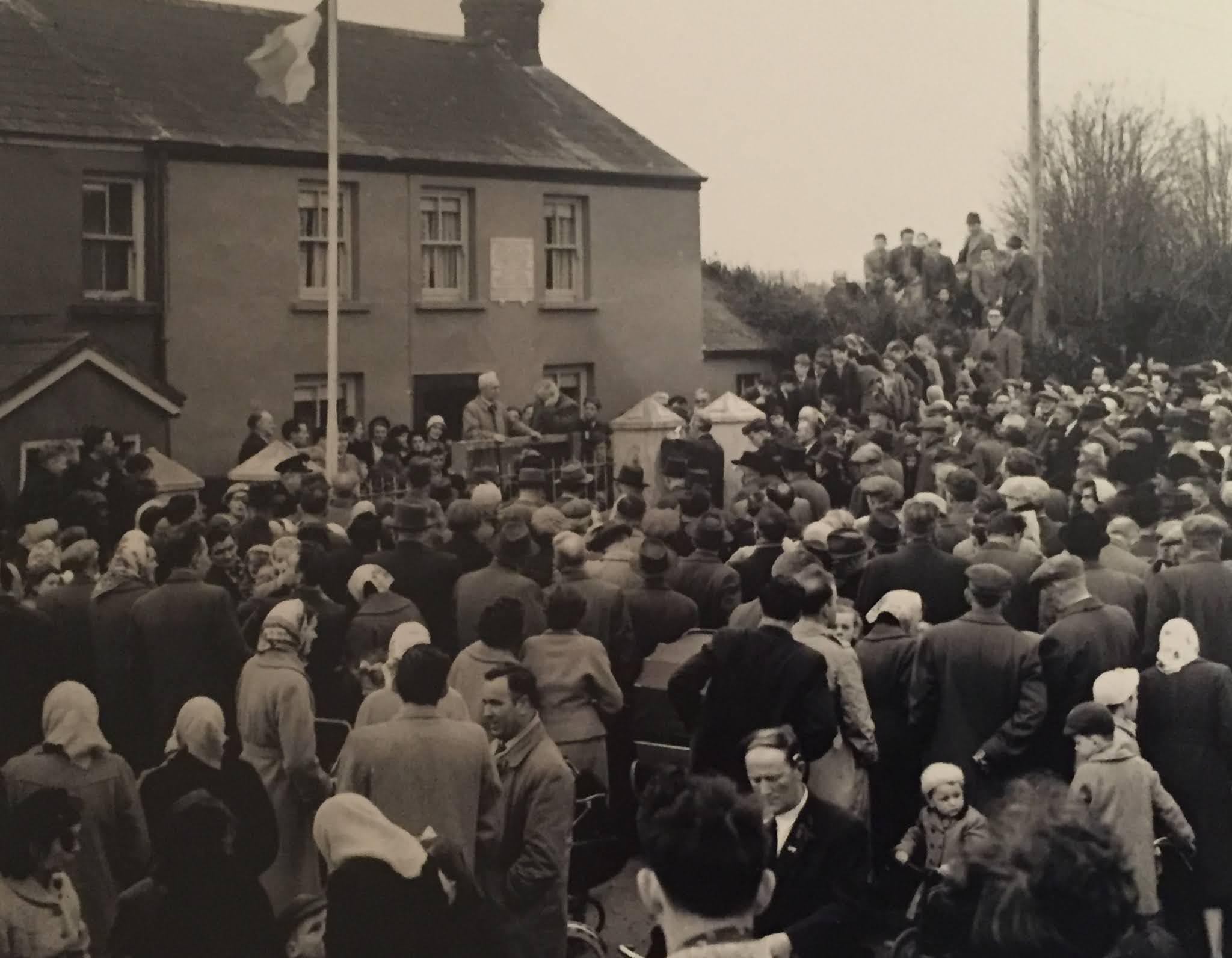
40 years later , John Joe Hegarty would make his final honour to Joe Murphy by arranging for a memorial placue to be placed on his family home and the name of Joe Murphy on the left pillar of the gateway. Many former colleagues turned up for the event including Tom Barry of  Flying Column fame  ; Sean Hegarty ( Brigade Commander No.1 Brigade following Terence McSwiney's death ) , Florrie Donoghue , Tom Croft and surviving members of " H " Comany including John Joe Hegarty who lead the colour party.


Placue Dedication to Joe Murphy
by former members of " H " Company 1960


Placue on wall of Joe Murphy house


Time wore on and in 2019 following intensive research and campaigning by many local groups , Joe Murphy's War of Independence Medal with Bar was finally awarded. This event took place at the City Hall in Cork where Lord Mayor Mick Finn presented the medal to Joe Murphy's Nephew , Harry Delaney. Joe Murphy had to wait 99 years for his Country to finally honour his memory. R.I.P.


Harry Delaney ( Joe Murphy's Nephew ) 
with Medal & Bar 2019
Cork City Hall
 
 
Joe Murphy
War of Independence Medal with Bar


*Acknowledgments:

Shirley Kelleher
Jim Hegarty
W.A. Hill ( Research )