Friday, April 15, 2022

Togher Learning Neighbourhood Expo - St. Finbarrs H.F. Club - April 6th 2022

On April 6th 2022 , the Barrs club hosted the Togher Learning Neighbourhood Expo. The event was opened by Cllr. Fergal Dennehy deputising for the Lord Mayor who welcomed all present. The event began with pupils from Togher Girls National School singing a multi lingual song in acknowledgement of the many Nationalities now studying at the school. Next up was a presentation to people of all ages including local legends Donie Og and John Dennehy in recognition of their community activism.

Togher Learning Expo leaflet


Togher Learning Neighbourhood stand


Fergal Dennehy addressing the Expo at the Barrs


The purpose of the Expo was to highlight the various local groups within Togher which included sports , education and historical interests. Togher Historical Association was represented by Kathleen O'Keeffe and Billy O'Brien and the stall attracted much attention. The table was covered with many rare photos from Toghers past including albums for people to browse through at their leisure. Former Barrs player Jim Hegarty paid a visit prior to his book launch the following night. John Dennehy also dropped by to offer his continuing support.

Jim Hegarty - former Barrs player


 Billy O'Brien & John Dennehy
 
 
Fergal Dennehy & Kathleen O'Keeffe


Togher Historical Association table


A quickstop tour was made of other stands which included most of the sporting clubs around Togher and the local primary schools and many others. Below are photos of each stand. Many thanks to all the organisations who turned up to promote Togher as a hotbed of activity for youngsters and matures alike.

Everton F.C est'd. 1958


L'Arche Community


Togher Community Association


Mrs. Manning and colleague


Togher Boys National School


Togher Athletics Club


Togher Boxing club


Togher Family Centre


Cork City Partnership

Friday, March 11, 2022

Townlands - 12/15 - Gortagoulane

 Gort an Ghabhláin - Field of the Fork - 401 Acres


Gortagoulane - ( Data from Townlands.ie )


Gortagoulane is thought to have been the seat of the Ui Mc Ceir tribe up to their eventual loss of power in the late 1100s. The fork in its title refers to the various streams which virtually encompass the land ; the Liberty stream which rises at its south eastern tip and flows under Corcoran's Bridge ( built by journeymen masons in the 18th Century and named after the farmers who commissioned its construction ) in a northerly direction meeting up with a winterborne stream which rises near its western boundary and an internal stream which rises inside its territory. The Glasheen River acts as its southern boundary with Doughcloyne making up its western boundary. The land to its extreme north is marsh or bogland and a possible fulacht fiadh ( ancient pit which was used for dyeing , bathing and brewing ) is located on its land where the Gortagoulane stream and the Liberty stream meet.


Remains of old Ashgrove Farm


Gortagoulane stream meets Liberty stream
( Probable site of Fulacht Fiadh )
 

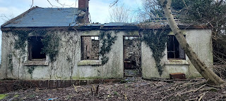
Derelict houses ( bought by Cork Airport ) near Corcorans
Bridge ( Possibly dwellings of Corcoran Brothers? )

There are 2 old houses named Ashgrove House and Ashgrove respectively which appear on 19th Century maps and are farmsteads. Another older residence once existed inland and which was accessed via a long laneway from Lehenaghmore before encountering a lodge ; this was Ashgrove Farm and all that remains of the structure are two right angled high stone walls. The land today houses Richardsons farm which is accessed from Doughcloyne and some private dwellings. In 1911 Census there was a total of only 8 inhabited houses in the entire Townland. Gortagoulane has two internal roads , Matthews Hill ( which emerges from Lehenaghmore and bisects the Townland as it exits ) and Wilson's Lane ( Ashgrove Close ) a.k.a. Ben Deebles Lane. The Townland's south eastern portion takes in part of the runway of Cork Airport.

Corcorans Bridge

Addresses ( Modern Era )

Wilson's Lane
Ashgrove Close
Matthews Hill
Ashgrove House ( Farm )
Ashgrove ( Farm )


Addresses/Structures ( Historical Era )

Fulacht Fiadh
Ashgrove House ( 2 walls remaining )
Corcoran's Bridge

Boundary

From a point near the airport following the Liberty Stream in a northerly direction under Corcorans Bridge to meet with the Gortagoulane Stream and following the direction of the old winterborne stream westwards in a meandering manner southwards until the access road/lodge into Richardsons Farm before moving southwards again to Wilsons Lane before joining the Glasheen River a little further on and tracing the stream all the way back to the Airport where it rises near the Liberty Stream.


Saturday, February 19, 2022

33rd Fieldwork Trip - 16th February 2022 - Culverts , Bridges & Progress

On Wednesday , 16th February 2022 , Togher Historical Association took to the road for the first time since September of 2021 to record the progress of the ongoing culvert works on Togher Road.  The immediate and stark changes which presented themselves was the filling in of the Gully by Greenwood Estate next to the Garage and the removal of the old stone wall completely. ( There is a raised surface now present which may accommodate street furniture and a lower hardcore base for a new pedestrian walkway ). Coupled with that was the culverting of the section of stream by Togher Cross and the disappearance of the old beveled stone wall and the cutting down of the trees which lined its banks. The last two sections of stream to remain daylighted since the 1840s was now erased from history and from sight. Liberty Stream a.k.a. Togher Stream is now no longer visible from Togher Cross to Coffey's Field. The New Culvert which has its beginnings alongside the old Southern Fruit Industrial Estate is a mind blowing 4 Metres Wide by 4 Metres Deep and follows a largely linear trajectory from Togher Cross to the Community Centre where it makes a sharp turn to run along Coffey's Field. The section of New Culvert by Southern Fruit is still under construction and will alter the original Stream's flow there into the concrete channel which also has an overflow culvert to cater for sudden rises in water.


Old gully filled in near Garage
( looking North towards Greenwood Estate )


Old Gully across from School
( Looking back towards Garage )
 
 
Looking towards Togher Cross
( Lanes old cottage on corner )


View of Lanes cottage and garage
( Lehenaghmore Road side )


Side view of Lanes cottage and Garage
( Looking back from Lehenaghmore Road to Togher Cross )


Close up view of Lanes garage and covered stream


Alternate view of Lanes cottage and Garage
( Lehenaghmore Road looking towards Togher Cross )


Close up view of Lanes cottage


Location of New Culvert by Southern Fruit


Original Togher Stream next to Southern Fruit
( To be culverted into new concrete channel - see next photo )


Culvert section under construction next to Southern Fruit
( Overflow channel on right )


Interior shot of Overflow Channel


1980s Pipes next to Southern Fruit
( Originally daylighted near stream on Togher Cross )


The group next made its way to the rear of SuperValu for a look at a piece of hisstory hidden in plain sight. The area on view in the photos was once known as Minnie's Orchard and existed right up to the 1960s when the road facing walls were demolished to make way for the then new Togher Shopping Centre in 1968. The surviving walls are encircled by Earlwood Estate which was built between 1958 and 1962.


Original stone wall to rear of SuperValu


Old stone wall to rear of Earlwood Estate


A spot check was made on some of Togher's remaining historical houses on Togher Road and Pouladuff Road. First on the list was a visit to the two storey semi-detached house on Ardmanning Hill which features in the famous harvest photograph from the 1950s. Research is still ongoing with it presently being thought to be Russell's dairy farm. However this has not conclusively been determined. Pouladuff Road beckoned for a brief look at 3 houses which stood before any modern development pre-1960s. The Laurels which is currently for sale with rumours that it is to be demolished to make way for new builds. The house is over 200 years old and is in private ownership. Next on the right hand side past Edward Walsh Road moving south was Bellvue House , an old two storey build and finally an old cottage. Research again is underway to unearth their past.


Russell's Dairy Farm? Ardmanning Hill


The Laurels , Pouladuff Road


Bellvue House , Pouladuff Road


Old cottage , Pouladuff Road


Next stop was a visit up Lehenagh Beg to look at the old Kelly's cottage. The site has been sold and plans are underway to build 16 new houses. The old once more makes way for the new. Evidence that not only is Togher changing , but that it is changing beyond all recognition.


Planning application near roadside


Front view of cottage


Kathleen O'Keeffe , Togher Historical Association


Land to rear to consist of 16 new dwellings

Final visit of the day was to the old railway bridge in Mahers Lane. Hard to believe that trains once ran under it and even harder to believe that it was the first time the group had looked at it. Even harder to believe is the fact that Togher still has 5 railway bridges intact! All part of the old Cork Bandon line. These will be covered in a future article.


Maher's Lane railway bridge
( uphill from Maher's Lane )


Mahers railway bridge looking back towards St James Cemetery


Close up view of Mahers Lane bridge

Friday, January 7, 2022

Townlands - 11/15 - Chetwynd

Chetwynd - Cheat The Wind - 219 Acres
formally Baile an Ghiolláin - Ballyginnane


Chetwynd -  (Data from Townlands.ie )


This Townland is unique in that it is the only one to have completely lost its original name in favour of a foreign one. Chetwynd , from the Old Welsh - " Cheat The Wind " - was the name imposed on it as of 1750 when the new landowners cruelly and arrogantly disposed of the older name. Its correct and ancient name was Baile an Ghiolláin or Ballingillan as noted by the Down Survey of 1658. The original name would have referred to the Ginnane family and the townland as being their home , as it predates the Norman Invasion of 1170. The possibility exists that the Ring Fort located in the Townland off Lios Cross may even have been their home. However by the time of the Cromwellian Confiscations of the 1650s we find the Ronaynes dispossessed and the Townland handed over to the Piggotts. It had a succession of tenants down through the years but finally in 1950 the Sweetnam family bought the property and land outright and still farm there today.


Chetwynd House 2014

Chetwynd had 2 big houses with the same name , one fronting onto Spur Hill ( Sweetnams as of 1950 ) acting as a farmhouse with another located on Meaghers Lane off Mahers Lane. Sadly this was demolished in 2018 with just its outbuildings remaining. It is perhaps most famous for the Chetwynd Viaduct , half of which is located inside its boundary. An original overbridge still exists on Mahers Lane. Chetwynd now plays host to the parish Cemetery , St. James.  Many private builds are located around the Townland most predominantly on Mahers Lane.


Chetwynd Viaduct 2014


Chetwynd has two internal streams which both join up with the Glasheen River and one which originates in Knocknamallavoge and flows on to turn west towards the Glasheen River near the viaduct. The Cork Bandon railway line once ran through the Townland and this is thankfully still evident by the presence of the two previously mentioned structures. The sport of bowling is famously connected with the Chetwynd Viaduct with Mick Barry " lofting the viaduct " in 1955. N.B.* - The Townlands southern boundary appears to have been moved several times since the 1840s which leaves the ring fort outside its borders. However the Blog will treat the original boundary in favour of the ring fort being in Chetwynd.

Chetwynd Townland Map - OSi 1840s


Addresses ( Modern Era )


Mahers Lane ( various private builds )
Meaghers Lane ( various private builds )
Viaduct Bar
Sweetnams Farm( Chetwynd House )
Chetwynd Viaduct

St. James Cemetery


Addresses/Structures ( Historical Era )

Ring Fort
Chetwynd House ( Demolished 2018 )
Chetwynd Viaduct ( Still extant )
Bandon Railway Line ( removed )
Mahers Lane overbridge ( still extant )

Water Pump ( still in situ )

Boundary ( shown in red on map )


From a point on the Bandon Road turning east to the rear of St. James cemetery cross country to emerge on Spur Hill by the water pump. Moving southwards along Spur Hill before turning west after the old Hegarty Sisters derelict cottage moving cross country to emerge once more on the Bandon Road just before the Viaduct Bar to follow the Glasheen Stream to the point started from.

Chetwynd ( Satellite View )


Wednesday, December 15, 2021

Townlands - 10/15 - Garrane Darragh

 Garrán Darach - Grove Of Oaks - 169 Acres

Garrane Darragh - ( Data from Townlands.ie )


Garrane Darragh as a Townland is perhaps one of the most mysterious of the group of 15 which comprise Togher. It seems to refuse to give up its ghostly past and secrets. However , closer examination of this area reveals that it once hosted 2 ring forts which in and of itself means ancient habitation. Sadly one of the ring forts has since the 19th Century been subsumed by agriculture and completely removed. One other possibly still exists to the rear of Bishopscourt Shopping Centre. Historically it was the abode of the Right Honourable Mr. Carey as shown by George Taylor and Andrew Skinner's "Maps of the Roads of Ireland", as Surveyed during 1777. It would seem that the entirety of the Townland was in the hands of same for many years. The 1911 Census shows the Barrett , O'Driscoll and Brien families as tenants on the farmland of the Careys.

Taylor & Skinner Road Map 1777


However bridging the gap in the ownership was a Mr. O'Leary who farmed the land until quite recently when it fell into receivership and lies in limbo. The outhouses are demolished whilst the big house is now boarded up. It would seem that the Townland was one massive farm used primarily for dairy farming. The Cork Bandon railway line once ran through the Townland and much of its former track can still be seen today ( see aerial photo below ). Today , part of Eagle Valley , Woodhaven and Garrane Dara makes up a portion of its Northern region with the Western portion of Doughcloyne Industrial Estate. The rest of the Townland is largely undeveloped.

Garrane Darragh House 2015
 

Remains of old Bandon Line ( semi circular arc )


Addresses ( Modern Era )

Woodhaven
South Ring Road ( portion )
Garrane Dara
Eagle Valley ( western portion )
Doughcloyne Industrial Estate ( western portion )
Garrane Darragh House ( Derelict )


Addresses/Structures ( Historical Era ) 

 
Garrane Darragh House ( Mr. Carey )
Tenant Farmers ( Barretts , O'Driscolls & Briens )
2 Ring Forts
Bandon Railway Line ( portion of )
Lodge ( Demolished )


Boundary

From a point on the western corner of Woodhaven following the Glasheen River in an easterly direction before taking a sharp turn across the South Ring Road and bisecting Doughcloyne Industrial Estate and Eagle Valley and moving south in an irregular fashion before turning westwards to the rear of St.James Cemetery crossing the Bandon Road briefly before moving again in a northerly direction following the Glasheen Stream and passing Bishopscourt Shopping Centre before ending at the point started from at Woodhaven.

Garrane Darragh ( Satellite View )